


Polar cold in Buenos Aires: the southern air covered AMBA with winter weather
He polar cold in Buenos Aires marked the beginning of the week with a scenario more typical of winter than the last days of October. The entry of a mass of frozen air from the south, confirmed by the National Meteorological Service (SMN) through satellite images, caused a sharp drop in temperature that took a large part of the Metropolitan Area by surprise.
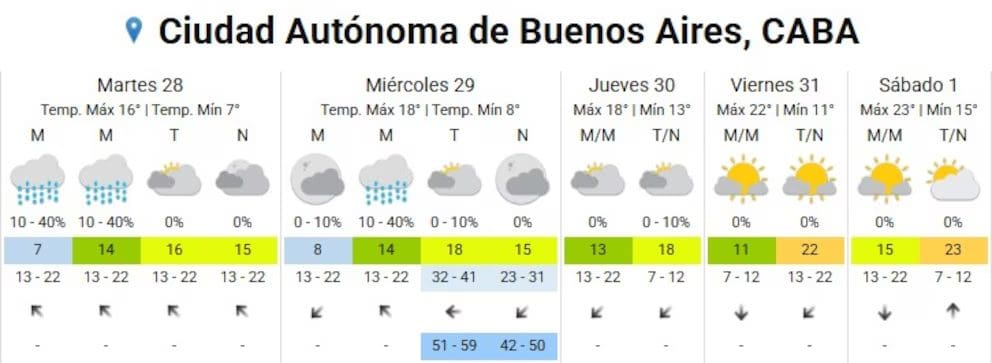
During the early hours of Monday, isolated drizzles were recorded, followed by a day of variable cloudiness and thermal values that ranged between 9 °C and 15 °C. Although the rains remained dispersed during the day, towards night the panorama changed and the probability of precipitation increased up to 40%, affecting different sectors of the suburbs.
The lowest minimums of the AMBA
Ezeiza registered the lowest temperature of the day, with just 8.3 °C, followed by Campo de Mayo (8.8 °C) and Merlo (10 °C). In towns such as El Palomar, Morón, San Fernando and Aeroparque the brands were similar. According to the specialized portal Meteored, all were below the historical average for October, estimated at 13.4 °C.
These values reinforce that the phenomenon was not isolated, but the result of a polar air mass that affected a good part of the center and north of the country.
Tuesday: the coldest day of the week
He National Weather Service anticipates that the cold air will continue throughout Tuesday, with morning showers and a sky that would only tend to improve in the afternoon. Temperatures will continue to decline, with minimums close to 5°C and maximums that will barely be around 15°C.
In fact, Tuesday could become the coldest day of the whole week, with gusts of up to 40 km/h from the southeast rotating east, and an even lower wind chill.
Wednesday with clouds and intense gusts
The SMN forecast maintains the possibility of showers during Wednesday morning. However, the weather would improve towards the afternoon, although the sky would remain mostly cloudy. Easterly gusts of up to 50 km/h are forecast, with a minimum of 8°C and a maximum of 18°C.
Although conditions will continue to be cold, a slight thermal recovery is expected towards the end of the day.
Thursday: slight rise in temperatures
Starting Thursday a progressive thermal recovery, although still with variable cloudiness. The SMN forecasts cloudy skies in the morning and somewhat clearer skies during the afternoon, with temperatures that will range between 13 °C and 18 °C.
The relief will be partial, since cold air will continue to be present in the early hours of the day, especially in suburban areas.
Friday: Sustained improvement ahead of new cold front
Friday will show a more noticeable improvement, with a minimum of 13°C and a maximum close to 22°C. Even so, the value will continue below the historical average for October (22.6 °C).
North winds will blow with moderate intensity, with gusts of up to 40 km/h. This change could influence the levels of the Río de la Plata, increasing the height of the waters in the coastal area.
New cold front for the weekend
In any case, the stability will not last long. According to Meteored, a new cold front It could advance between dawn and Saturday morning, generating rains and storms of varying intensity.
Before its arrival, temperatures would reach their weekly peak, with minimums of between 15°C and 17°C and maximums of up to 24°C, according to the European ECMWF model.
The SMN recommends staying tuned for upcoming updates, as the trend could change in the following hours.

Overview
After a start to the week unusually cold and wet, the weather in Buenos Aires will tend to improve gradually between Thursday and Friday. However, the possibility of a new thermal drop during the weekend remains valid.
For more information on local forecasts, you can consult the weather section of our site or visit the official portal of the National Weather Service.
Subscribe to Uruguay Al Día
Receive the most important news directly in your email. Clear, independent and updated information every day.
Follow us on WhatsApp
Join our official channel and receive alerts, news and exclusive content from Uruguay Al Día.
🔔 Join the WhatsApp channel


