


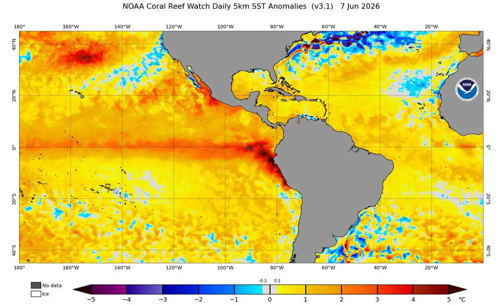
The equatorial Pacific thermometer does not lie, and the data coming from monitoring stations is beginning to seriously worry the meteorological community. What began as routine monitoring has transformed into surveillance of a phenomenon that promises to be, at the very least, disruptive. According to the latest updates from the Brazilian consulting firm Metsul and reports from the US NOAA, we are facing the accelerated advance of an “El Niño” that could mark a before and after in modern climate records.
It is not just a question of numbers, although the numbers are scary: temperature anomalies on the sea surface have registered a sustained rise. Off the coasts of Peru and Ecuador, the temperature is already showing deviations that, for specialists, are clear indicators that the warm phase of the phenomenon is gaining strength.
A phenomenon with a significant history
To put it in context, current projections do not point to a minor event. Some climate models already place the potential intensity of this El Niño at the same level—or even higher—than the 1982-1983 and 1997-1998 episodes. Those years were recorded in the collective memory due to the floods, droughts and natural disasters that redrawn the map of several regions of South America.
What makes 2026 particularly critical is the speed with which ocean and atmospheric conditions are shaping up. “The acceleration is real,” comment meteorological sources, while the world watches as the anomalies in the Niño 1+2 region already reach levels not seen since the end of last year. The question roaming the halls of weather services is not whether it will come, but how profound the impact will be once it peaks in the second half of the year.
A “super El Niño” on the way?
The possibility that we are facing a “super El Niño” is a card that experts are on the table. This category is not used lightly; It is reserved for extreme events that drastically alter the global climate. While there is what meteorologists call the “predictability barrier” — a zone of uncertainty that occurs between March and June — the consistency of current models is what is really keeping everyone on alert.
Each new update seems to confirm the trend: intensity estimates have been going up, not down. As NOAA prepares to make the official announcement in the coming days or weeks, the climate board is already moving. The change in monitoring systems, now incorporating the impact of global warming, suggests that this phenomenon will not be a repetition of the past, but rather a challenge with new variables.
Prepare for the unpredictable
For the populations of South America, the message is clear: vigilance must be maximum. An event of this magnitude knows no borders. Torrential rains, disruption of agricultural cycles and variations in local temperatures are almost guaranteed consequences.
The human impact is, at the end of the day, what really matters. Behind every colored map and every technical index there are families, crops and infrastructure systems that must withstand the clean and jerk. If history is of any use to us, it is to know that in the face of events of this scale, prevention is not an option, but a necessity. We are, once again, at the mercy of the power of the Pacific, observing how the thermometer moves towards red zones that are already beginning to set the agenda for the entire continent.
Subscribe to Uruguay Al Día
Receive the most important news directly in your email. Clear, independent and updated information every day.
Follow us on WhatsApp
Join our official channel and receive alerts, news and exclusive content from Uruguay Al Día.
🔔 Join the WhatsApp channel


