


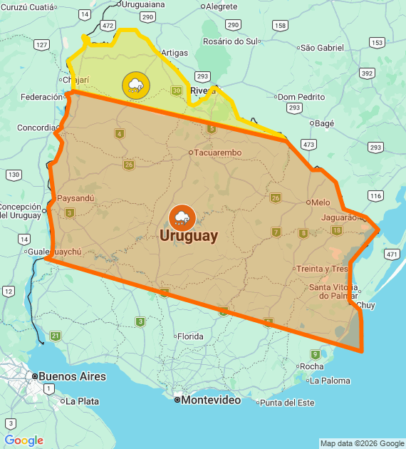
Atmospheric instability has taken center stage this Thursday, May 7. The Uruguayan Institute of Meteorology (Inumet) issued a Inumet orange alert that affects a vast area of the national territory due to the advance of a cold front. With a probability of occurrence greater than 75%, the phenomenon promises to generate occasionally severe storms, characterized by a strong load of water in short periods and violent climatic manifestations.
Associated risks and description of the phenomenon
According to the official report, the areas under orange warning could experience gusts of very strong winds, hail and intense electrical activity. The cold front interacts with an unstable air mass, which enhances the formation of clouds with great vertical development. The authorities recommend taking extreme precautions, especially in open areas and while traveling on routes National, given that precipitation could be abundant or copious, drastically reducing visibility.
At the same time, a yellow warning is maintained for the extreme north and part of the coast, where occasionally strong storms. Although less intense than the orange zone, the yellow level warns of the possibility of abundant rains and strong gusts of wind that should not be underestimated by the local population.
Localities under orange alert (Important risk)
The orange warning, in force from 05:45 a.m., includes all of the departments of Cerro Largo, Peach, Paysandu, Tacuarembó and Treinta y Tres. Likewise, it affects specific areas of other departments:
-
Florida: Chapel of Sauce, Cerro Chato, Goñi and Nico Pérez.
-
Lavalleja: José Batlle y Ordoñez, Jose Pedro Varela, Pirarajá and Zapicán, among others.
-
Black River: Young, New Berlin, Algorta and surrounding areas.
-
Leap: City of Salto, Termas del Arapey, Termas del Daymán and much of the departmental interior.
-
Rocha: Chuy, Lascano, Devil's Point and San Luis in the middle.
-
Rivera: Vichadero, Minas de Corrales and Paso Hospital.
Localities under yellow alert (Preventive risk)
The yellow level mainly includes the department of Artigas in its entirety, in addition to specific areas of Rivera (Tranqueras, Masoller) and Salto (Belén and Sarandí de Arapey). In these areas, although the phenomenon is expected to be less severe, constant monitoring is maintained for possible changes in the trajectory of the cold front.
Inumet has confirmed that the situation will continue under close surveillance and an update of the report is expected at 08:45 hours, or earlier if conditions require it. Citizens are urged to remove objects that may be blown by the wind, check drains and stay informed through official channels.
Subscribe to Uruguay Al Día
Receive the most important news directly in your email. Clear, independent and updated information every day.
Follow us on WhatsApp
Join our official channel and receive alerts, news and exclusive content from Uruguay Al Día.
🔔 Join the WhatsApp channel


