Heat wave in Uruguay with peaks above 30°C in the north. Metsul notes anomalies; Inumet forecasts cloudiness and isolated thunderstorms.
The thermometer has climbed again. The north is preparing for a heavy Wednesday , while the central-southern region is looking ahead to the subsequent air mass shift. The models agree on the trend, although they differ on the nuances.
The heat wave in Uruguay predicts a challenging afternoon in Artigas, Salto, Rivera, and Paysandú, with above-normal highs and peak temperatures expected to exceed 30°C, according to Metsul. In Montevideo, the increase will be moderate and fluctuate toward the weekend.
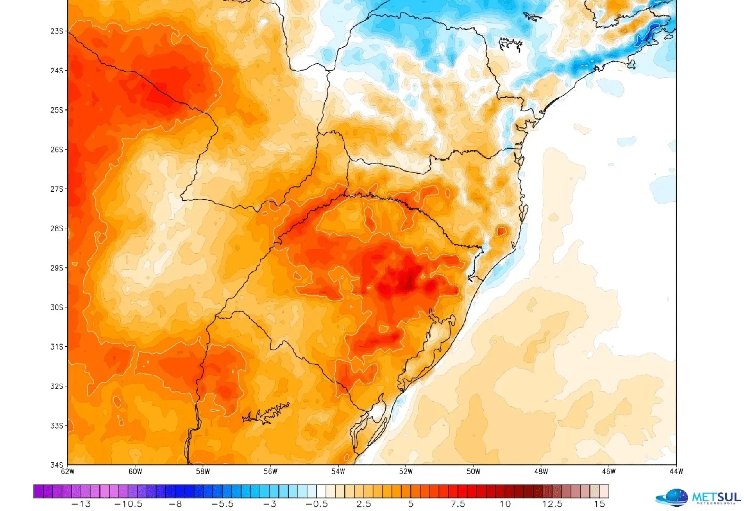
Heat wave in Uruguay: What Metsul's maps show
The Brazilian agency released an anomaly field showing positive deviations over the north. The reading is clear: warmer air than the seasonal average and a thermal peak concentrated along the northeast coast. Although not a record, the rebound will be noticeable in the afternoon.
Heat wave in Uruguay: Metsul maps and maximum temperatures
In X, meteorologist Mario Bidegain predicted deviations of +2°C to +6°C for Chile, Argentina, and Uruguay between Thursday the 16th and Wednesday the 22nd (GFS model). He also noted that, in Montevideo, the ceiling would be around 24°C between Tuesday the 14th and Thursday the 16th; then, a slight drop between Friday and Sunday.
For his part, Guillermo Ramis said on Informativo Sarandí cold front would pass through on Thursday and that Saturday would be the coolest day in the capital, with highs close to 18°C. Together, both describe a thermal swing: it rises, gives way, and rises again , typical of October.
#temperature anomalies expected over South America, according to GFS, from THU16 to WED22Oct. Positive deviations (orange) +2° to +6°C are expected over #Chile , #Argentina and #Uruguay . Negative deviations over the south and Atlantic coast of #Brazil (blue) -1° to -4°C. pic.twitter.com/k8TnOTcRAn
— Mario Bidegain (@mario_bidegain) October 15, 2025
Inumet Forecast: Cloudy, foggy, and a chance of thunderstorms
The Uruguayan Meteorological Institute ( Inumet ) forecasts increased cloudiness, fog, and mist in several areas. For Thursday and Friday, there is a chance of scattered showers and thunderstorms in some regions, with a low probability in others. Minimum and maximum temperatures are expected to remain unchanged from the previous day. In summary: warm weather in the north, with localized instability and moderate amplitudes.
Heat wave in Uruguay: Artigas, Salto, Rivera, and Paysandú
-
Artigas and Salto: High highs from midday; high wind chill due to humidity.
-
Rivera and Paysandú: heavy afternoon, relative relief at night if the wind is southeast.
-
Southern and central coast: warm weather, but with variable cloudiness that may cut peaks.
-
Metropolitan area: steady rise; Thursday's front could bring drizzle and wind.
warm hours the day.
Thermometer in the Rio de la Plata language: what does "above normal" mean?
It's not just about the absolute number. The anomaly measures how far the temperature deviates from the historical average. A sustained +3°C temperature during the afternoon is felt outside and requires adjustments to logistics: hydration, clothing, transportation times, and outdoor activities. On the other hand, a high maximum with intermittent cloud cover can be more bearable.
Heat wave in Uruguay: practical recommendations
-
Hydrate frequently. Avoid direct sunlight between 11:00 and 16:00.
-
Screen sensitive populations: children, the elderly, and people with chronic illnesses.
-
Reschedule strenuous physical activity to early morning or late evening.
-
Indoor cross ventilation; use fans or air conditioning responsibly.
-
Pets: fresh water and permanent shade.
Hot North, Variable South: Why It Happens
October combines increasing radiation and subtropical air inflows. If the wind shifts north and the cloud cover eases, the north quickly warms up. On the other hand, the proximity of the Río de la Plata cushions peaks in the south, especially if the east brings breezes and the front arrives in a timely manner.
Is it raining again? Short-term signs
Metsul and local forecasts predict occasional instability on Thursday and Friday. This is not a widespread event. There may be showers, some thunderstorms, and rapid improvements. However, humidity is expected to remain high, sustaining high wind chills even without full sun.
Montevideo and metropolitan area: thermal round trip
The capital is expected to be in an intermediate zone. Before the front, temperatures will be 22–24°C (72–75°F) and variable skies. Afterward, a cooler Saturday and a stable Sunday, with room for outdoor activities during warmer hours. If the wind shifts south early, the low will arrive earlier; if it delays, the drop will not be felt until evening.
Speed reading by region
-
Northeast: frankly hot, risk of suffocation during peak hours.
-
West coast: hot afternoon, occasional breeze from the river.
-
Center-east: increasing cloudiness, isolated showers.
-
Southeast and coast: greater variability, smaller thermal amplitude.
What can change from one day to the next
Models like GFS and Meteoblue adjust run by run. A cloud cover that wasn't there, or an accelerating front, shifts the heat line by a couple of hours. Therefore, it's a good idea to check the daily Inumet and not just rely on the map image.