On August 19, 2025 , the country woke up under a yellow meteorological warning issued by the Meteorological Institute. The alert responds to the formation of an atmospheric depression that began to affect the national territory since dawn, generating occasionally strong storms , with a high degree of probability (greater than 75%) of abundant rainfall in short periods, occasional hail, intense electrical activity and strong gusts of wind .
What does a yellow warning mean?
A yellow warning indicates that meteorological phenomena pose a risk to the population, although less severe than orange or red warnings. However, when the probability of occurrence exceeds 75% , as in this case, the recommendation is to take preventive precautions to minimize risks in daily life, transportation, and urban and rural infrastructure.
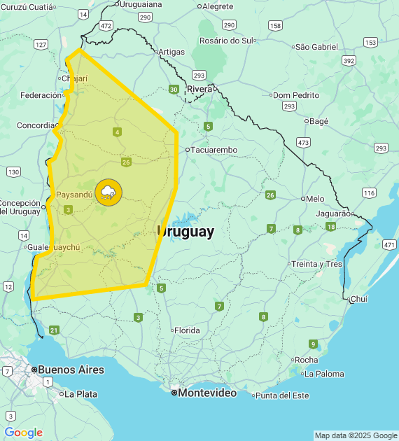
Departments and localities under warning
The warning covers a wide swath of the country, including towns in the departments of Artigas, Durazno, Flores, Paysandú, Río Negro, Salto, Soriano and Tacuarembó .
-
Artigas: Baltasar Brum, Colonia Palma and Sequeira.
-
Peach: Baygorria, Carlos Reyles, Centenario and Feliciano.
-
Flowers: Andresito, Ismael Cortinas and Juan José Castro.
-
Paysandú: the entire department under warning.
-
Río Negro: the entire department affected.
-
Salto: Albisu, Arapey, Belén, Biassini, Constitución, Garibaldi, Arapey Hot Springs, Daymán Hot Springs, among other towns.
-
Soriano: Dolores, Mercedes, Palmitas, Villa Soriano, Risso and rural areas.
-
Tacuarembó: Bull Pass, Piedra Sola, Cuchilla de Peralta, Rincón del Bonete and Drums.
The geographical extent of the warning demonstrates the magnitude of the atmospheric system and the need to monitor its evolution .
Meteorological factors at play
Atmospheric depression is the main trigger of instability. These systems generate a rapid rise of warm, humid air , which, when colliding with cold air, produces intense storms with significant vertical development .
In this scenario, phenomena such as:
-
Spot hail in storm cores.
-
Strong winds with gusts exceeding 70 km/h.
-
Frequent electrical discharges that increase the risk of local fires or damage to electrical installations.
-
Torrential rains in short periods , capable of causing flooding in urban areas.
Main risks of storms
strong winds, hail and heavy rain combine , the risks to the population increase significantly:
-
Falling trees and branches on public roads.
-
Power outages due to damage to distribution lines.
-
Traffic accidents due to reduced visibility and slippery roads.
-
Crop damage due to hail or excess water.
-
Damage to roofs and light structures due to wind gusts.
Recommendations for the population
In light of this situation, meteorological and emergency authorities suggest:
-
Stay informed at all times through official announcements.
-
Avoid driving on flooded streets or streets with accumulated water.
-
Secure loose objects on balconies, patios and rooftops.
-
Unplug sensitive electrical appliances to prevent shock damage.
-
Avoid outdoor activities during thunderstorms.
-
Protect yourself indoors in case of hail.
Impact on key sectors
Transportation: Domestic routes may experience flooding and low visibility, increasing the risk of accidents. River and air transportation may also experience delays or cancellations.
Agriculture: Producers should be aware of the risk of hail and excess water that could affect sensitive crops.
Livestock: Livestock in open fields can suffer stress from wind and hail, so it is recommended to shelter them.
Energy: Utility companies often reinforce crews to respond to power outages in rural and urban areas.
Short-term outlook
While the current warning applies to the early hours of August 19 , weather models indicate that instability could extend throughout the day , even with further warning updates. Depending on the evolution of the atmospheric depression, higher warning levels may be issued if storms increase in intensity or frequency.
The importance of prevention
A key aspect of dealing with adverse weather events is prevention . It's not just about responding to the emergency, but also anticipating risks : planning travel, protecting property, keeping drains clean, and following official instructions.
Experience shows that communities that prepare in advance suffer fewer impacts than those that react at the critical moment.