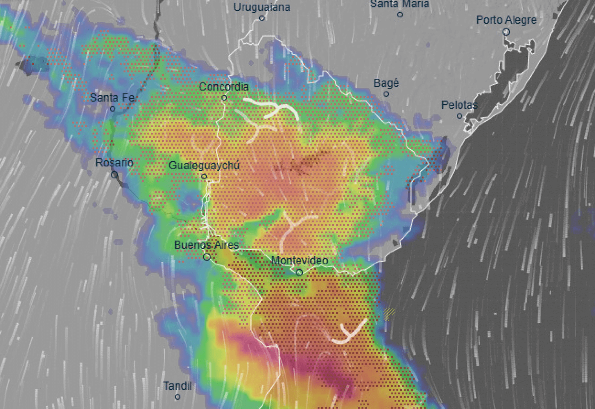
The storm warning in Uruguay indicates the onset of rain starting Saturday night, first along the western coast and then spreading to the rest of the country during the early hours of Sunday, including the metropolitan area. Inumet and independent meteorologists indicated that the passage of the frontal passage will concentrate the most intense activity between early morning and midday in various departments.
In its special advisory, the institute indicated that a humid and unstable air mass favors strong and, at times, very strong storms. It also predicted the entry of a frontal system from the southwest, gradually moving northeastward. Under this scenario, strong wind gusts , intense thunderstorm activity, and hail could occur in storm zones.
Storm warning in Uruguay: expected timing and most exposed areas
According to the official forecast, the storm is expected to begin on the western and northern coasts in the evening and early morning. As the front advances, the storm is expected to reach the south and metropolitan area, where rainfall is expected beginning Sunday morning. In the northeast and east—Artigas, Rivera, Tacuarembó, Cerro Largo, and Treinta y Tres—the storm is expected to continue through Sunday afternoon and evening, and into the early hours of Monday, with heavy rain and strong storms.
For Montevideo and the metropolitan area, hourly forecasts predict no rain until early Sunday. From then on, significant accumulations are expected until early afternoon. The front will then tend to move, and the weather could gradually improve, with scattered drizzle toward the evening and a drop in temperature as the air mass shifts.
Meteorologists monitoring radar and numerical models provided converging readings: the peak of rainfall in the capital and surrounding areas is expected between Sunday morning and noon. They also warned that Saturday would be warm, while Sunday would be unstable due to the passage of the front. The storm warning in Uruguay includes local variations, so the call is to review official updates.
Most significant weather over #PBSAS and southern #Uruguay according to the #ECMWF , for DOM05 at 02:00 hrs local time (left) with storms passing over #CABA and at 07:00 hrs (right) passing over southern #Uruguay and #Montevideo . (Areas of storms in violet). pic.twitter.com/oIszSCJbnX
— Mario Bidegain (@mario_bidegain) October 4, 2025
Storm warning in Uruguay: useful recommendations and checks
The weather system's recommendations point to simple preventive measures. Check drains, secure loose items on balconies and rooftops, and plan your travels ahead of time if work or family activities require traveling during the heaviest rain . On the road, it's recommended to reduce speed, increase braking distance, and avoid flooded intersections. It's also a good idea to avoid sheltering under trees during lightning strikes.
For homes and businesses, it's a good idea to check the condition of gutters and review power outages . Those who work outdoors should consider taking breaks indoors during peak electrical times. For outdoor Heritage Day events, organizers should consider rescheduling events or creating temporary shelters if the storm falls during peak attendance times.
The storm warning in Uruguay includes the possibility of hail in intense convective units. This means sheltering vehicles under cover whenever possible and protecting windows or sensitive objects. Health and emergency services usually reinforce their guards during bad weather; in the event of any incident, calling the emergency numbers early will speed up the response.

As with any frontal event, temporary improvements may occur behind the main line, followed by new cells that reactivate rain and thunder. This intermittent occurrence is common. The recommendation is to continue monitoring through official channels until the event is deactivated. As the front moves northeast, the southwest and south will tend to stabilize with cooler air.
Link: Uruguayan Meteorological Institute (updated warnings and forecasts) → https://www.inumet.gub.uy/


