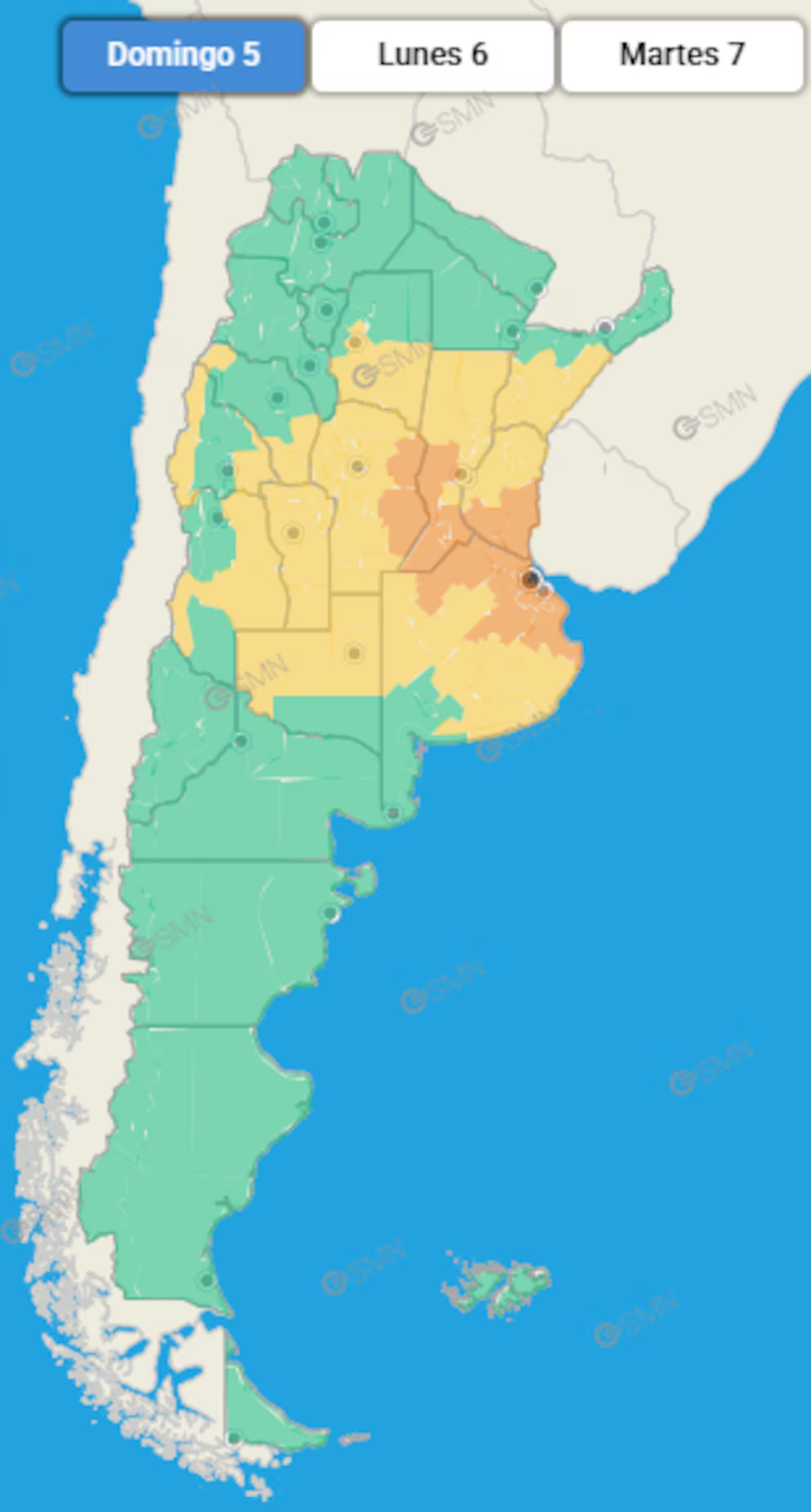
The SMN's storm warning was renewed for this Sunday, covering the Greater Buenos Aires (AMBA) and several areas in the central and eastern parts of the country. The National Meteorological Service indicated that the storms could intensify with thunderstorms, hail, and strong gusts. The agency forecasts a partial improvement starting Monday, with cloud cover and a drop in temperature.
The warning places areas of the Greater Buenos Aires Province (AMBA), the Atlantic Coast, northern Buenos Aires Province, southern Entre Ríos, the southern half of Santa Fe, and eastern Córdoba under orange level. This level implies potentially dangerous phenomena for the population and requires attention to official announcements. A yellow wind alert for sectors of northern Buenos Aires Province, southern Santa Fe, and eastern Córdoba, with expected speeds between 35 and 50 km/h and gusts that could exceed 75 km/h.
SMN Storm Alert: Scope, Impacts, and Estimated Accumulations
The forecast includes storms of varying intensity , with the possibility of hail and gusts that could locally exceed 90 km/h. Accumulations of between 40 and 80 millimeters are estimated for the day, not including the rainfall recorded on Saturday. The distribution will be uneven: convective cores can concentrate larger amounts in short periods, increasing the risk of flooding in urban areas and on roads with limited drainage.
Regarding temperatures, the National Meteorological Service (SMN) maintains its forecast for a warm environment in northern parts of the country . For the AMBA region, Sunday is expected to see a low near 16°C and a high near 21°C. In Santa Fe and Corrientes, highs could exceed 30°C before the arrival of cooler air.
Authorities recommend basic self-protection measures. During thunderstorms, staying indoors reduces the risk of electric shock. Avoiding contact with electrical installations and protecting sensitive equipment are low-cost , high-impact measures. Those who must travel are advised to stay inside their vehicles if a storm strikes, reduce speed, increase braking distance, and avoid attempting to cross flooded streets.
The National Meteorological Service (SMN) reminds everyone that if water enters the home, it is advisable to turn off the power supply until the situation is under control. If someone is affected by the storm, contact local emergency services. It is advisable to have an emergency backpack with a flashlight, radio, documents, and a charged phone, which will be useful in case of power outages or emergency transportation.

Practical recommendations and horizon for improvement
Municipalities and service providers are urged to check drains, remove loose items, and organize operations in case of possible falling branches or temporary outages. Merchants and vendors can provide secure awnings and additional anchors. At home, securing flower pots and other objects on balconies prevents them from being blown off by gusts. At work, scheduling outdoor tasks outside of peak periods reduces contingencies.
Urban traffic tends to slow down in heavy rain. Planning your outings, opting for public transportation when possible, and checking detours to anticipate delays. For those traveling on the road, checking the condition of tires, windshield wipers, and lights improves safety. In case of hail, seek shelter under a roof and avoid stopping under trees.
According to the extended forecast, the weather is expected to improve starting Monday over the metropolitan area. Mostly cloudy skies are expected, with temperatures dropping—lows near 10°C and highs around 18°C—and gradually stabilizing as the frontal system moves away. During the week, temperatures are expected to rise without exceeding the hot threshold, with periods of variable cloudiness.
The SMN storm warning will be updated with new information from radars and models. It is recommended to follow official reports and adjust activities to the most impactful times. In neighborhoods with limited drainage, small actions such as clearing storm drains and not removing trash during rain can help prevent flooding .
National Meteorological Service – Current warnings and alerts → https://www.smn.gob.ar/


