MADRID, 14 (EUROPA PRESS)
Rapid glacial melting is increasing water volume in at least 10% of Asia's high mountain rivers, including major rivers such as the Yangtze, Amu Darya and Syr Darya,
According to a new comprehensive study of the region, flows in parts of these upstream rivers have nearly doubled in a decade.
Communities that rely on rivers for energy could benefit from increased flow, but excess sediment carried by the water could clog infrastructure. The increase is currently being observed specifically in upstream portions of rivers, but downstream communities could face the same consequences as glaciers continue to melt.
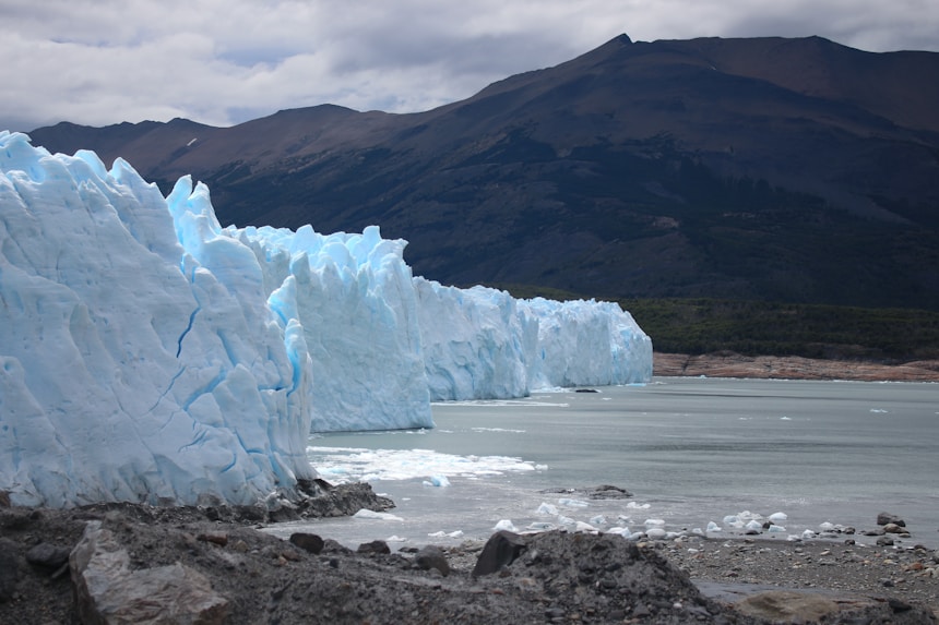
Spanning the Himalayas and the Hindu Kush, and mighty rivers such as the Yangtze, Yellow, and Indus, High Mountain Asia is a complex geographical region that supplies water to some two billion people. Rivers are fed primarily by glaciers, snow, and rainwater, but river systems are changing as a result of climate change, which affects temperature, monsoon season, and droughts. Previous research has projected that glaciers in High Mountain Asia will lose between 29% and 67% of their total mass by 2100.
The new study, published in AGU Advances, investigated how the amount of water flowing through the river has changed as a result of melting glaciers and snow, as well as changes in precipitation. This is the first study to analyze the entire mountain range and its river, and focused on examining the impact of each individual section of these rivers.
"Increased river discharge offers short-term benefits, such as more water for hydropower and agriculture, but it also signals increased sediment and glacier loss," said Jonathan Flores, a University of Massachusetts engineer and lead author of the study, in a statement. "If these glaciers continue to shrink, their contribution of meltwater to river systems will decrease, threatening long-term water availability for downstream regions."
The research measured more rivers than previous studies and divided them into 8-kilometer segments, providing more detailed and personalized results.
Researchers found that 10% of rivers experienced an increase in discharge, or the amount of water flowing through them, during the study period from 2004 to 2019. On average, these rivers saw an 8% annual increase in flow. Larger river stretches with more than 1,000 cubic meters of water flowing through them per second, such as the Yangtze, saw an average increase of more than 2% annually. Upstream increases may not correlate with an increase in downstream flow, as is the case for many of the rivers measured.
DOUBLE-EDGED SWORD
The results show a double-edged sword. An increase in water can benefit agriculture, electricity, and overall water consumption, but an increase in water discharge directly correlates with an increase in river energy, or the amount of sediment, such as sand, silt, and gravel, transported through the river.
Sediment is natural in waterways, but increased sediment can have consequences. Increased sediment can slow down machinery inside hydroelectric plants, accumulate in dams used to store water during dry seasons, and harm river ecosystems with vulnerable wildlife.
"Natural aquatic habitats may be altered by this growing trend, and previously stable ecosystems may be altered and modified," Flores said. Rivers in the western part of high mountain Asia are fed by glaciers, while rivers in the east are filled primarily by rainfall. As a result, it was primarily western rivers that experienced an increase in discharge because climate change is accelerating glacial melting.
They used more than a million images from Landsat and PlanetScope satellites to track changes in the rivers, confirming their estimates with flow measurements at various points in the region.
The information collected is open source and accessible to anyone. As the construction of new dams or hydroelectric plants is planned, this information could be used to increase the plants' water capture capacity, resulting in greater water storage or increased electrical capacity.
"Most water infrastructure, such as dams, are designed based on historical data," Flores said in a statement. "In this study, we observed increasing trends in the data, which can be a determining factor in decision-making, planning, and design optimization."
Of the 1,600 dams or planned dams measured in the study, 8% experienced an increase in flow capacity, which implies greater movement of sediment through the dams. Flores explained that the increased sediment could increase the pressure on machinery, which would have to move not only the water but also all the sand and soil that it begins to accumulate. Additionally, dams used to store water during the dry season could fill with sediment, limiting their capacity.